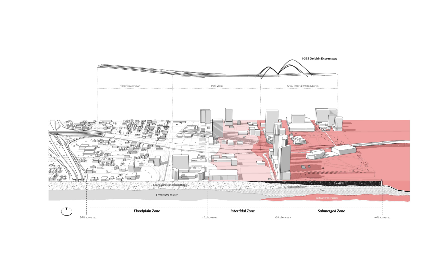
"When President Eisenhower’s Highway expansions reached Miami in 1969, the city government decided that the historically-black Overtown neighborhood would be the construction site. The construction of the I-395 Overpass was a cataclysm.

The disenfranchised community fell into poverty and the new infrastructures fragmented what remained. Today, the government has approved the widening of the overpasses, threatening to destroy what remains of this historic cultural hub. This project uses the highway understructure as an armature for an elevated pedestrian walk in the hopes of fostering more meaningful connections to buildings adjacent to the highway, elevating Overtown into a resilient neighborhood of the future.

This project will take a stand against this unsustainable reality in favour of a richer and more considerate system that landscape architecture can bring. Through the design development process, the boundaries of aesthetic phenomenology will be pushed beyond convention, often dealing with the surreal and surprising, while thoroughly remaining true to the conditions and disturbances that shape the site. Although the highway serves its functional purposes, it carries with it the pain and injustice of those whom it displaced and the places it destroyed. This is a place in need of interpretation and narration, a place wounded by the insensitive decisions of the past and left to heal with no treatment and where the landscape can be a driver of social change.

Michael Chang, BSLA ’21

Course:

LA 4010 Urban Design Studio

Zaneta Hong, Faculty Advisor

Semester:

Fall 2020

Growing Infrastructure and a Vanishing Community Fabric

The vacant underpass and understructure of the I-395 overpass are public lands that currently remain desolate. This prompted my interest in exploring how to adapt this space to become a place that fosters connectivity and resilience.

Cataclysm Follows the Construction of I-395

The once-thriving historically black community was displaced to residential ghettos on the outskirts of Miami, as the Highway proved to be another obstacle separating residents from the city. As new transit infrastructure cuts through the Overtown site, local communities are fragments, as the highway stands as a central obstacle to pedestrian connectivity.

Threats of Sea Level Rise

Coastal Flooding along this rock ridge region will convert this try coastal urban into a littoral zone, with distinct flood-risk, intertidal and submerged areas by 2100.

Utilizing the Existing Highway Understructure

The elevated walkway will be supported by the existing highway infrastructure. In some
moments, it will suspend from above, and in others, be buttressed from below. The elevated Walkway will be supported by the existing highway infrastructure. The understructure of the highway will be used to hang and support an elevated walkway system. Existing joist beams will be used to hang the elevated, while piers will be a foundation to girder the elevated.

Linking Overtown with an Elevated Walkway System

Using the structural principles of the design, the concept will be extended across the entire underpass, connecting Overtown with local amenities and new developments. To improve connectivity, the project deploys grade separation strategies to provide safer right-of-way for pedestrians and cyclists, while also maintaining an efficient flow of foot and vehicular traffic.