

Hafez Ahmad
Post Doc, Natural Resources and the Environment Section, Ashley School of Global Development and the Environment
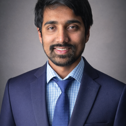
Hafez Ahmad is an oceanographer, geospatial scientist, and environmental researcher whose work integrates oceanography, fisheries science, remote sensing, geospatial analysis, machine learning, and quantitative environmental modeling. He is currently a Postdoctoral Associate at Cornell University, where he works on aquatic and fisheries research involving quantitative acoustic methods, autonomous survey platforms, spatial analysis, and environmental data science. Hafez earned his Ph.D. in Earth and Atmospheric Sciences from Mississippi State University in May 2026. His doctoral research focused on the integrated assessment of water-quality dynamics in the western Mississippi Sound, combining field observations, remote sensing, hydrodynamic and watershed modeling, and phytoplankton community analysis. His work included the development of computational and machine-learning approaches for environmental monitoring and the integration of large-scale geospatial and observational datasets. Before completing his Ph.D., Hafez earned an M.S. in Wildlife, Fisheries, and Aquaculture from Mississippi State University, where his research focused on geospatial analysis and management of invasive Silver Carp in the Lower Mississippi Alluvial Valley. He worked with the USGS Cooperative Fish and Wildlife Research Unit and applied GIS, remote sensing, hydrological connectivity, and spatial modeling to fisheries and aquatic-resource management. He also holds undergraduate and graduate training in Oceanography from the University of Chittagong in Bangladesh and completed an exchange program in Marine and Environmental Sciences at Florida Gulf Coast University, where he gained field and laboratory experience in marine ecology, seagrass, coral reefs, and fisheries. His research interests span fisheries acoustics and biomass estimation, marine and freshwater ecology, physical oceanography, coastal and estuarine processes, remote sensing, GIS, machine learning, and environmental data science. His fisheries-acoustics work includes quantitative echo integration, target-strength analysis, spatial biomass estimation, and the application of autonomous platforms to aquatic surveys. His broader environmental research uses satellite observations, field measurements, geospatial statistics, hydrodynamic models, and machine-learning methods to investigate water quality, aquatic ecosystem dynamics, habitat distribution, and environmental change. Hafez has also worked in marine conservation and spatial planning. As a Marine Data Management Officer with the Wildlife Conservation Society Bangladesh Program, he contributed to marine biodiversity data management, geospatial analysis, marine spatial planning, protected-area planning, and biodiversity monitoring in the Bay of Bengal. His earlier marine research included field studies of coral reefs, seagrass ecosystems, mangroves, coastal habitats, and marine biodiversity. His current research interests include improving aquatic ecosystem monitoring through autonomous observing platforms, hydroacoustic surveys, remote sensing, spatial statistics, and artificial intelligence. He is particularly interested in developing interdisciplinary approaches that connect physical and biological processes with quantitative environmental observations. His work seeks to improve the accuracy, spatial coverage, and efficiency of environmental and fisheries assessments while providing information useful for ecosystem management and conservation. Hafez has published and contributed to research spanning oceanography, environmental science, remote sensing, machine learning, fisheries, and aquatic ecology. His recent work includes applications of ensemble machine learning and satellite observations to water-quality dynamics and machine-learning approaches for evaluating and predicting hypoxia in the Gulf of Mexico. Beyond research, Hafez has been involved in professional and scientific organizations, including the American Fisheries Society,
Education
Doctor of Philosophy (PhD) — Earth & Atmospheric Sciences Mississippi State University, Starkville, MS, USA\ Master of Science (MS) — Wildlife, Fisheries & Aquaculture Mississippi State University, Starkville, MS, USA Bachelor's— Oceanography University of Chittagong, Chittagong, Bangladesh
Recent Research
As an environmental scientist with a PhD in Earth and Atmospheric Sciences, I bring a strong interdisciplinary background spanning observational oceanography, marine ecology, coastal zone management, Earth surface processes, spatial data science, mapping, remote sensing, floodplain management, strategic planning, and advanced data analysis and visualization in both 2D and 3D environments. My work integrates field observations, satellite remote sensing, geospatial analytics, and machine learning to address complex environmental and coastal system challenges.
Awards & Honors
1. Mississippi State University, Graduate School, Hall of Fame Scholar 2025–2026
2. College of Arts & Sciences, Graduate student Hall of Fame 2025–2026
3. College of Arts & Sciences, Outstanding Doctoral Student 2025–2026
4. Gulf of America Coastal Acidification Network (GCAN) award-2026
Courses Taught
• Teaching Assistant in Remote Sensing of the Physical Environment (17 students) F2025
• Maps and Remote Sensing (2 sections- 39 students) Fall 2025
• Advanced Remote Sensing (12 students) Spring 2026
• Maps and Remote Sensing (2 sections- 30 students) Spring 2026
1. Ong'ondo, F. J.& Ahmad, H. (2026). Modeling Land Cover Dynamics Across Wildlife Management Areas and Surrounding Landscapes to Inform Conservation Planning. Environmental Management
2. Ahmad, H., & Dash, P. (2026). Resolving spatiotemporal water quality variability in a river-influenced estuarine system using high-frequency autonomous surface vessel observations. Marine Pollution Bulletin.
3. Ahmad, H., Jose, F., Nabi, M. M., Jhara, S. I., & Ong'ondo, F. J. (2026). Spatial and Temporal Patterns of Vegetation Greenness in Response to Climate Variability and Land-Use Changes in the Irrawaddy Delta. Earth Systems and Environment.
4. Ahmad, H.(2026). Integrated assessment of water quality dynamics in the western Mississippi Sound: Combining field observations, remote sensing, material transport, and phytoplankton community structure. Theses and Dissertations. 16280. https://scholarsjunction.msstate.edu/td/ 16280.
5. Ong’ondo, F. J., Ahmad, H., Dash, P., Jose, F., Nabi, M. M., Jhara, S. I., & Shoemaker, D. J. (2026). AI-driven geospatial modeling of urban expansion and environmental impacts. Remote Sensing in Earth Systems Sciences.
6. Ahmad, H., & Dash, P. (2026). Ensemble machine learning and landsat observations reveal seasonal and spatial dynamics of water quality in a river-influenced estuarine system. Science of Remote Sensing. https://doi.org/10.1016/j.srs.2026.100401
7. Ahmad, H. (2025). High-Resolution Spatiotemporal Monitoring of Water Quality and Trophic Status in Bay St. Louis Using Sentinel-2 NDCI Time Series on Google Earth Engine. Transactions in GIS, 29(8), e70166. https://doi.org/10.1111/tgis.70166.
8. Ahmad, H. (2025). Discharge–Chlorophyll-a Relationship and Seasonal Variability in the Northern Gulf of Mexico. Ocean-Land-Atmosphere Research, 4, 0120. https://doi.org/10.34133/olar.0120
9. Ahmad, H., Miranda, L. E., Dunn, C. G., Boudreau, M. R., & Colvin, M. E. (2025). Hydrologic Connectivity in Floodplain Systems: A Multiscale Review of Concepts, Metrics, and Management. Hydrological Processes. https://doi.org/10.1002/hyp.70260
10. Ong'ondo, F. J., Meng, Q., Chesire, D. K., Njoroge, P., Aqil, T., Ahmad, H., & Malaki, P. A. (2025). Towards integrated frameworks for assessing bird species richness using citizen science and geospatial data. Rangeland Ecology & Management, 103, 218–229.
11. Ahmad, H., Jose, F., Dash, P., & Jhara, S. I. (2025). Detection, Tracking, and Statistical Analysis of Mesoscale Eddies in the Bay of Bengal. Oceans. oceans6030052
12. Ahmad, H., Jose, F., Dash, P., Shoemaker, D. J., & Jhara, S. I. (2025). Hypoxia in the Gulf of Mexico: A machine learning approach for evaluation and prediction. Regional Studies in Marine Science, 104363. https://doi.org/10.1016/j.rsma.2025.104363
13. Ahmad, H., Jose, F., Nabi, M. M., Jhara, S. I., & Ong'ondo, F. J. (2025). Land Use and Land Cover Dynamics of Irrawaddy Delta: Remote Sensing Analysis and Future Projection. Remote Sensing Applications: Society and Environment. https://doi.org/10.1016/j.rsase.2025.101607
14. Islam, M. S., Dash, P., Liles, J. P., Ahmad, H., Nur, A. M., Panda, R. M., & Moorhead, R. J. (2025). Spatiotemporal dynamics of cyanobacterial blooms: Integrating machine learning and feature selection techniques with uncrewed aircraft systems and autonomous surface vessel data. Journal of Environmental Management, 381, 124878. https://doi.org/10.1016/j.jenvman.2025.124878
15. Ahmad, H., Jose, F., Dash, P., Shoemaker, D. J., & Jhara, S. I. (2025). Machine Learning-Based Estimation of Chlorophyll-a in the Mississippi Sound using Landsat and Ocean Optics Data. Environmental Earth Sciences.
16. Ahmad, H., Miranda, L. E., Dunn, C. G., Colvin, M. E., & Dash, P. (2025). Confluence of time and space: an innovation for quantifying dynamics of hydrologic floodplain connectivity with remote sensing and GIS. River Research and Applications. https://doi.org/10.1002/RRA.4426
Contact Information
G09 Fernow Hall
Ithaca, NY
Tompkins County
ha463 [at] cornell.edu